When 2020 started we never could of imagined that this would be our reality. That sickness and death would take over our world. That not shaking hands, hugging or even getting within six feet of others would be the standard. That masks would be a new mandatory fashion accessory. Nobody could’ve known we’d be here this year. As we got further into the year we realized that this was going to be it, our new “normal”. The week before the state of Washington shut down, I took myself on three hikes in a matter of five days. Right after that they closed all the trails. A month of so later they reopened them, and whether it was because I had the time, because I love the mountains, or to numb the fact that we all suffered some kind of loss, I took myself to the mountains. Over and over again. I’ve been an avid hiker for the last three of so years but this year was different. It was imperative that I spent time outside. I needed to fill my soul with that which makes me happiest (other than my husband, love you!). I needed to escape and I wanted to use my summers off as a teacher to the best of my ability. So I did!
I hiked over 250 miles, over 53,000 feet of elevation, and over 20 hikes, multiple of which were backpacking trips. I’m sure some people’s stats are higher but to me this is a lot. It’s a significant amount. Enough that I decided out of all the amazing places I’ve been this summer I want to share my top 5 favorite ones with all of you! I’ve picked only from day hikes because I plan to write a little something special about my backpacking trips, because they certainly were something special. So here we go!
Spectacle Lake – Okanagan-Wenatchee National Forest, Washington


Distance: 22 miles roundtrip
Elevation: 1500 ft.
Review: Spectacle lake is a long day hike. It’s not difficult in the sense that it’s super steep, although most of the gain comes in the last 3 miles, but it’s a lot of miles. It’s the longest day hike I’ve done! It’s a beautiful trail that is nice and flat for the first 6 miles and passes another lake (Pete Lake). Depending on time of year, but probably likely at any time, you’ll have a large water crossing that will require you to either take off your shoes and socks and walk through water up to your knees, or trudge through with your shoes on and let them air dry as you continue on. The next few miles you start to gain elevation as you head closer towards the lake and hike along part of the PCT. When you turn off towards the lake, you’ll lose some elevation which you’ll have to climb back out on your way back. Don’t worry thought, it’s really short and steep but doable. The lake is beautiful and the mountains in the backdrop make it ever better. I suggest taking a swim, as I do with any alpine lake I visit. Carrying a floatie adds some weight but sure makes floating in a freezing cold lake a little more enjoyable. Should you choose to do this as an overnight, there are designated camp areas and even a privy toilet perched on a hillside for your comfort. The road is long but doable for all vehicles. Either way this hike is a must do!
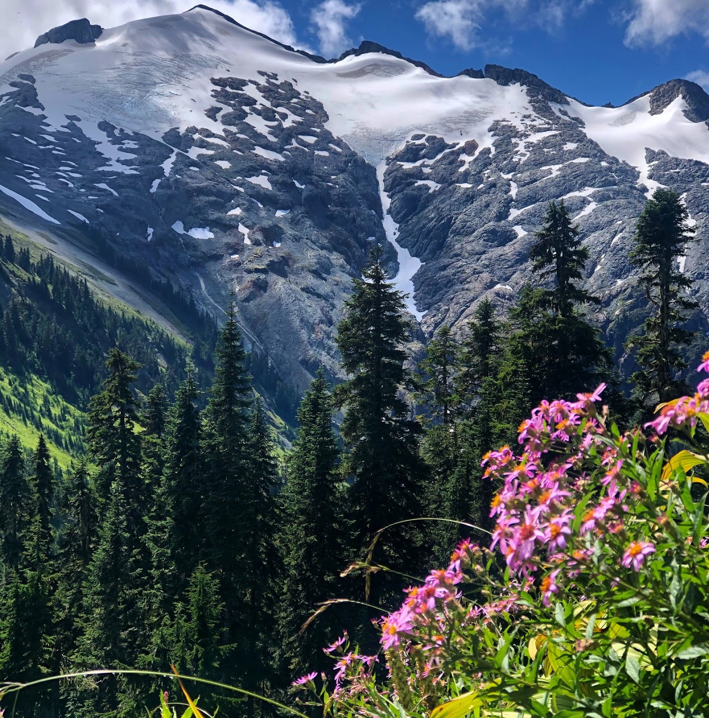
No Name Lake – Deschutes National Forest, Oregon


Distance: 5.5 miles
Elevation: 1420 ft.
Review: Want to get an amazing view of the peaks in Oregon? And maybe Southern Washington if you’re lucky? Then you need to do this hike! This hike is worth every mile. The trail is exposed the entire way so you’ll get views the whole time. Don’t forget to turn around and catch a glimpse of the surrounding peaks. The trail is a steady climb and steep right at the end before you reach the top but worth it. The end is always the steepest right? There are a lot of camping options up there as well but please remember that should you choose to camp you need to be 200 ft. from the lake. Once you reach the lake you’ll head around it on the right until you reach your last hard push that will take you to the top of the ridge overlooking No Name Lake. If you have a clear day you’ll also be able to see The Sisters, Mt. Bachelor, Mt. Jeffereson, Mt. Wasington, Mt. Hood, and maybe even Mt. Adams! We went up for sunrise and I absolutely recommend the early start to see Broken Top in the morning glow. Be warned: the road is rough and you will need a high clearance vehicle to reach the trailhead. It also gets really crowded so going early will help you beat the crowds and hopefully find some solitude.
Anderson and Watson Lakes – Mt. Baker-Snoqualmie National Forest


Distance: 6 miles roundtrip
Elevation: 1100 ft.
Review: If you’re into refreshing, crystal clear alpine lakes then this hike is for you! I’d had this one on the list for quite some time, so I was glad to finally make it up there, especially glad it was summer time because I would’ve been bummed to miss the chance to swim in Watson Lake. This hike has two lakes (well technically three). The first of the lakes is Anderson. On trail there will be an offshoot on the right that will take you over to Anderson Lake. It’s nothing special but still a pretty alpine lake and worth it if you’re already on the trail. Head back to the main trail and continue on until you reach Watson Lake. However, in order to get to the larger and prettier lake, which is Upper Watson, you have to continue to the left once you hit Lower Watson. Trust me when I say the extra bit is worth it. Not only is it arguably the largest alpine lake I’ve hiked to, but also the clearest. In places it was over 20 feet deep and I could see all the way to the bottom! Definitely freezing but in my opinion worth the swim. The catch with this trail is that a lot of the elevation comes on the way back to the car. It’s almost a reverse hike. You do very little uphill travel to get to the lakes and most of it on the way back, so mentally prepare yourself for that. The road is a little bumpy but you can probably do it in any vehicle. I can’t wait to revisit this place!
Hannegan Pass and Peak – Mt. Baker-Snoqualmie National Forest

Distance: 10.4 miles roundtrip
Elevation: 3100 ft.
Review: This hike surprised me in the best way. I had only recently discovered it by doing some research from a photo I saw on Instagram. I had never heard of it but it looked like the views were stunning should we get lucky enough to be up there on a clear day. Well lucky we were! Although Mt. Baker was hidden in the clouds the entire time we were up there (might’ve seen the top of her once), we were still greeted with views of Ruth Mountain, Mount Shuksan, and the Nooksack Ridge to the West and peaks of British Columbia to the North. It’s one of the best 360 degree view hikes I’ve done and I’m definitely planning to do this as an backpacking trip next time. This trail is quite deceiving. It starts off with a very gradual gain for about 3 miles. The next mile you gain about a 1,000 ft. as you reach the turn off for Hannegan Peak trail. If you stop at Hannegan Pass, there are some campsites there and the trail also continues on for another 7 miles connecting with the Cooper Ridge Loop. We took the left at the pass and headed up to Hannegan Peak. Here’s where it gets spicey. At this point, you’ve hiked 4 miles and completed about 2,000 ft. of climbing. With one mile remaining and 1,000 ft. left, it’s a steep push to the top. Then end is always the hardest part of the climb. Once we arrived we were greeted with stunning views. I love the North Cascades and it continues to put me in awe and wonder of the great outdoors. I can’t wait to do this as an overnight and see sunrise from the top. The road to the trailhead has a few potholes but can be avoided. Get out and do this hike in the summertime!
Perry Creek- Mt. Baker-Snoqualmie National Forest


Distance: 10.5 miles rounds trips
Elevation: 3400 ft.
Review: Perry Creek trail was another one of those hikes that had been on my list for a long time. I had done a lot of the hikes off Mountain Loop Highway that were under 10 miles so it was time to branch out and start stretching my legs some more. Perry Creek starts at the same trailhead as Mount Dickerman (also a fantastic hike). This trail has it all; forest, waterfall, stream, wildflowers, mountain views, and some small lakes. The area is also a natural research area so be sure to leave no trace and stay on trail to protect the plant life. The trail starts off gradual with only 1,000 ft. of gain in the first 3 miles. Then in the last 2.5 you continue upward another 2,500 ft. It is a lot of gain but it’s a pleasant climb as it’s consistent and spread out over the 2.5 miles stretch. When we did this trail we were graced with a fun water crossing that required either walking straight through or tip toeing across some wobbly rocks and logs. We managed to stay pretty dry. Near the top you reach an area that opens up and seems to be it but don’t stop there! Keep on going until the whole forest opens up and you reach expansive views of peaks all around. You’ll get up real close and personal with Glacier Peak and it’s a great spot for a lunch break. If you choose to continue on, you can head up to Mount Forgotten’s summit. The road is paved all the way to the trailhead and if you’re feeling really strong and adventurous you could come back down and hit up Mount Dickerman right after. Either way, you can’t go wrong with this one.
If you have any more questions directly related to these trails or others in the area please reach out! I’ll talk hiking any time, any day. Also, www.wta.org and www.alltrails.com are great resources for trails in the PNW. Use these sites to find distance, elevation, directions, weather, and trip reports.
Stay tuned for my top 5 fall hikes of 2020!
Stay Curious
